Restoring Water. Reviving Fields. Rebuilding Livelihoods.
-Ishita Dixit, Executive, PRADAN
Every transformation begins with a simple possibility. In Dava village, where rainwater once disappeared down barren slopes and livelihoods depended on a single uncertain crop, that possibility took the form of collective action. What followed was not merely the revival of land and water, but the rebuilding of confidence, dignity, and hope for an entire community.
Introduction
This is the story of Dava village, located in Sindri Gram Panchayat of Baghmundi Block in Purulia district, West Bengal. A story of transforming degraded land into green lushes of agricultural prosperity. Within Dava lies the Kundatanr hamlet, home to 65 families belonging to the Other Backward Class (OBC) Mahato community. Once marked by vast stretches of barren upland, locally known as gora-tanr, the landscape stood as a stark reminder of the poverty and uncertainty faced by its residents.
Today, this same land hums with agricultural activity throughout the year, sustaining the livelihoods of dozens of families and emerging as a powerful example of watershed-led rural transformation in the region.
Pre-Intervention Phase: Problems, Challenges, and Treatment Potential
The Crisis of Water and Livelihoods
Almost a decade ago, in 2017, the reality in Kundatanr was harsh. The hamlet's landscape was dominated by tanr land, a local term used in the Chotanagpur Plateau region to describe elevated uplands characterized by low organic matter, poor moisture retention, undulating, highly dissected topography, moisture-stress vulnerabilities, and reliance on hardy crops and seasonal forestry rather than intensive agriculture, and high susceptibility to erosion. Unlike the fertile lowlands, which naturally retain water and support paddy cultivation, tanr lands lie on higher slopes where rainwater rapidly runs off during the monsoon, leaving the soil dry for much of the year. In Purulia's undulating terrain, these uplands are among the most challenging agricultural landscapes, often remaining underutilized or supporting only low-productivity cultivation.
Dependent entirely on rain-fed agriculture, the hamlet's 65 families, each owning an average of just 1.4 acres of land, relied primarily on a single paddy crop cultivated during the monsoon. Paddy, the region's principal crop and an integral part of local farming traditions, was grown with the onset of rains regardless of rainfall variability. Once harvested around November, the produce barely sustained households for eight months. A small portion was sold in the market, while the rest was retained for self-consumption. In the lean months that followed, families often had to ration food, borrow money, migrate for work, and worry constantly about household expenses and their children's education.
Water scarcity further compounded these challenges. The village's few borewells began drying up by February, while handpumps often failed by March. Women had to walk long distances, often close to a kilometre, to fetch drinking water. While the exact distance varied because households were scattered across the hamlet, water sources were generally located around 900 metres to one kilometre from the village centre. The problem was not only the availability of water but also its quality. During the summer months, as safe drinking water sources dried up, many families were compelled to rely on unsafe or contaminated water sources, increasing their vulnerability to water-borne diseases such as diarrhoea, dysentery, and skin infections. Limited access to sanitation facilities and safe water management practices further heightened these health risks. Frequent illnesses often resulted in additional healthcare expenditures and loss of workdays, placing a significant burden on already fragile household economies. During the lean months, when food stocks were depleted and income opportunities were scarce, these unexpected medical expenses pushed many families deeper into debt and financial insecurity. In such conditions, cultivating a second crop or irrigating farmland beyond the monsoon season seemed impossible.
The availability of other livelihood opportunities was extremely limited. Most men depended on daily wage labour in nearby villages, undertaking work such as house construction, brick-making, paddy transplantation, and harvesting. Only a very small proportion, around 1–2 percent migrated to distant places for work, as most families feared exploitation and financial scams associated with migration to unfamiliar areas.
The average annual household income hovered around ₹40,000, barely sufficient for survival, let alone economic stability or growth. With an average family size of five members, this translated to roughly ₹666 per person per month, an amount that had to cover food, healthcare, education, clothing, agricultural & livestock needs and other essential needs. During the lean months, when food stocks ran low and wage employment became scarce, households often struggled to meet even their most basic expenses. Any unforeseen expenditure, particularly on healthcare or social obligations, frequently pushed families into debt. In such circumstances, access to quality education remained largely out of reach and was often viewed as an unaffordable aspiration rather than an achievable opportunity.
Treatment Potential
As discussions with villagers and field observations revealed, the very landscape that constrained livelihoods also held the key to transformation. Kundatanr is situated within the undulating terrain of Purulia, where tanr lands with an elevation of around 3-8% slope gently towards medium and lowland agricultural fields. During the monsoon, large volumes of rainwater flowed rapidly down these slopes, carrying fertile topsoil with them before eventually draining away. While the village received seasonal rainfall, very little of it was retained within the local ecosystem.
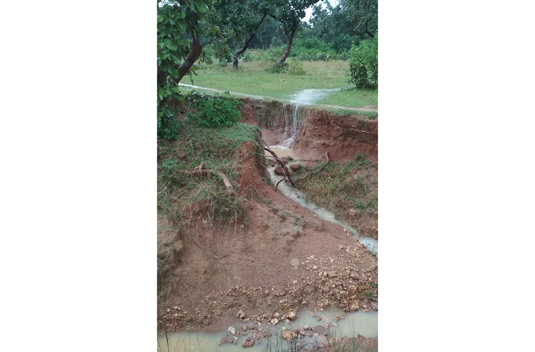
Fig. Topography of Kundatanr before intervention
This topographical reality highlighted a significant opportunity. If the runoff generated from the uplands could be slowed, captured, and conserved through appropriate watershed planning, the degraded tanr lands could gradually be restored and brought under productive use. Water-harvesting structures, soil-moisture conservation measures, and plantation-based treatments had the potential not only to reduce erosion but also to improve groundwater recharge and support agriculture beyond the monsoon season.
Since watershed treatment follows a ridge-to-valley approach, beginning from the highest elevations and gradually moving downstream, treating the upland ridge areas became critical. For years, these lands had remained largely unproductive as rainwater rushed unchecked down the slopes, carrying away fertile topsoil and leaving behind dry, degraded terrain.
However, transforming an entire watershed landscape could not be achieved by individual farmers acting in isolation. Since water, soil, and drainage systems cut across farm boundaries, any meaningful intervention required collective planning, community participation, and shared responsibility.
Fortunately, the first seeds of such collective action had already been sown in 2014 with the formation of Self-Help Groups (SHGs). Over the next few years, these groups evolved beyond savings and credit platforms to become important spaces for dialogue, mutual support, and collective decision-making. By the time PRADAN began engaging with the village, by 2017 a foundation of trust, community organisation, and women's leadership had already been established. This social capital would prove critical in mobilising the community around a shared vision of watershed restoration and long-term livelihood transformation.
Intervention Point and Changes Realized
November 2017: The turning point
A major shift began in November 2017, when PRADAN started working in Kundatanr under the state-level Usharmukti watershed programme. Building on the existing strength of the SHGs, the team posed a simple yet powerful question to the community: "What would it take for Kundatanr to become a self-reliant village?"
The women sat with the question for hours, discussing, debating, and slowly attempting to imagine a different future for their families and village.
The process was further strengthened through exposure visits to successful watershed villages in Bandhudi (West Bengal) and occasional night camps. Initially, however, the villagers remained deeply hesitant. Many feared that sharing land records or participating in planning exercises might eventually lead to outsiders or government departments encroaching upon their land. Building trust therefore became the first and perhaps the most difficult challenge.
To address these concerns, repeated orientation meetings were organised and a small village committee was formed with the support of local leaders and influential community members. Similar apprehensions were also observed in neighbouring villages, where people feared that sharing land records, participating in surveys, or allowing technical assessments could eventually lead to loss of control over their land. Overcoming these fears required patience, transparency, and continuous engagement.
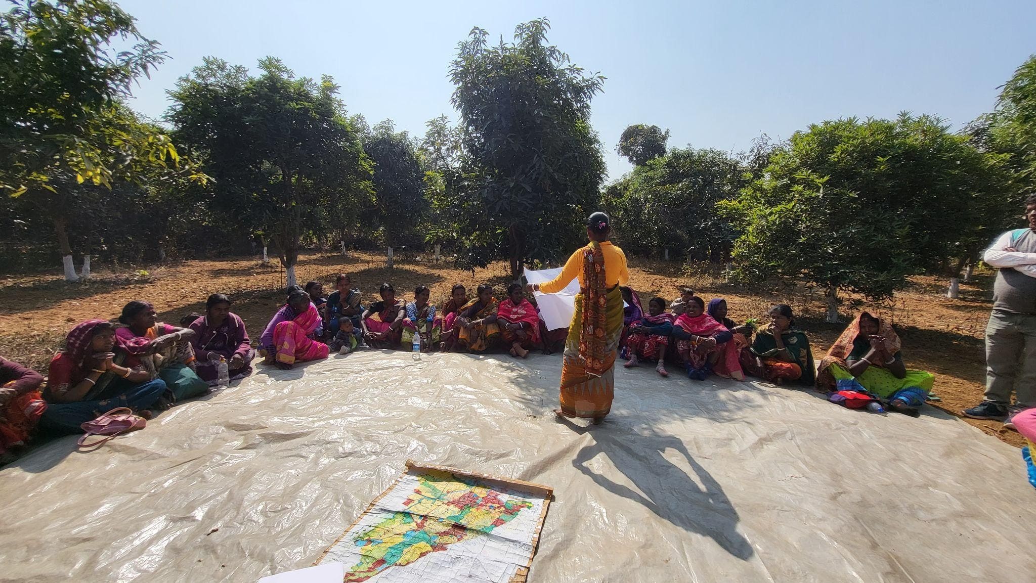
Over the next four to five months, PRADAN’s team, village committees, and community members engaged in an intensive participatory planning process. Through village meetings, transect walks, Participatory Rural Appraisal (PRA) exercises, resource mapping, and household-level discussions, villagers collectively analysed their landscape, identified problem areas, and explored potential solutions. Through these participatory exercises, conducted using village maps and extensive community engagement, nearly 626.31 acres of degraded privately owned uplands, medium uplands, medium lowlands, and lowlands were identified for interventions such as plantations, water harvesting structures, and soil and moisture conservation works.
Community members walked across their fields together, tracing the flow of rainwater, identifying erosion-prone areas, mapping existing water sources, and discussing how different parts of the watershed were interconnected. This collective understanding helped prioritize interventions based on the landscape's natural drainage patterns and the community's needs.
Fig. A village meeting in process in Kundatanr around intercropping planning
Exposure visits to successful watershed villages further helped build confidence by allowing community members to see similar transformations firsthand. Gradually, as villagers became active participants rather than passive beneficiaries, doubts began to diminish. The planning process evolved into a platform for dialogue, learning, and collective decision-making. What initially began with hesitation slowly transformed into a shared sense of ownership and possibility, as the community came together to envision and shape its future.
At the centre of this vision was the transformation of 25.6 acres of barren gora-tanr upland owned by 18 farmers into a mango plantation supported by water-harvesting infrastructure. This intervention emerged as the “crown jewel” of the watershed plan. Since watershed treatment ideally begins from the ridge and moves towards the valley, treating this upland ridge area became critical. Earlier, the land remained largely unproductive and a few parts densely covered as jungle, with rainwater rapidly flowing away unused and causing erosion.
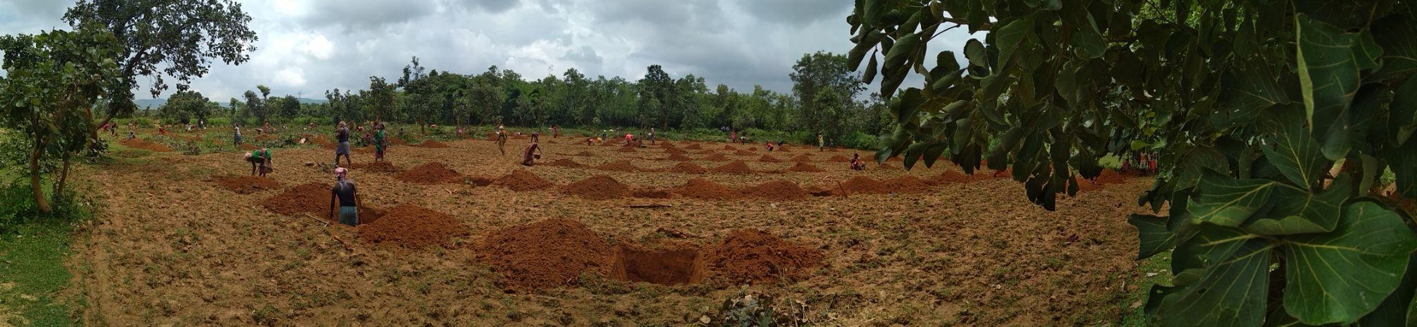
Fig. Preparing pits for mango plantation
Alongside the plantation work, the village also planned to develop a network of 19 water-harvesting structures, primarily hapas, used for irrigation and fisheries. Of these, eight structures were to be constructed under the Usharmukti project, while three existing structures were later re-excavated and one new constructed with support from the ICICI Foundation for Inclusive Growth. Together, these interventions laid the foundation for year-round agriculture and diversified livelihoods in Kundatanr.
April 2018: Collective Action
Many farmers, including those from the neighbouring village of Torang and Kundatnr too, were initially reluctant to participate in the proposed orchard development initiative. At this critical stage, women leaders such as Maloti Mahato and Surubali Mahato played a pivotal role in building trust and mobilising the community. They spent days conducting meetings, speaking with families, and explaining the long-term collective benefits of the initiative.
As the women leaders recalled, the message was simple: “This orchard belongs to all of us. We will protect it together, and both our children and future generations will benefit from it.”
Gradually, the idea of collective planning, farming and shared responsibility began to resonate with the villagers, bringing farmers together around a common vision for the future.
May-Aug 2018: Implementation Phase
May 2018 marked the beginning of visible transformation in Kundatanr. Nearly 150 people from 65 families participated in the implementation process, of whom around 90 were women. Together, they undertook a range of Natural Resource Management (NRM) interventions, including the construction of water-harvesting and soil conservation structures, excavation of hapas for water storage, land treatment activities, and the digging of pits for orchard development.
One of the most ambitious initiatives was the establishment of a community mango orchard. Spread across the lands of multiple farmers, the orchard required extensive preparation, from pit digging and land development to plantation and protection measures. Alongside this, the NRM structures helped slow down rainwater runoff, reduce soil erosion, and improve groundwater recharge, laying the foundation for more reliable water availability in the years to come.
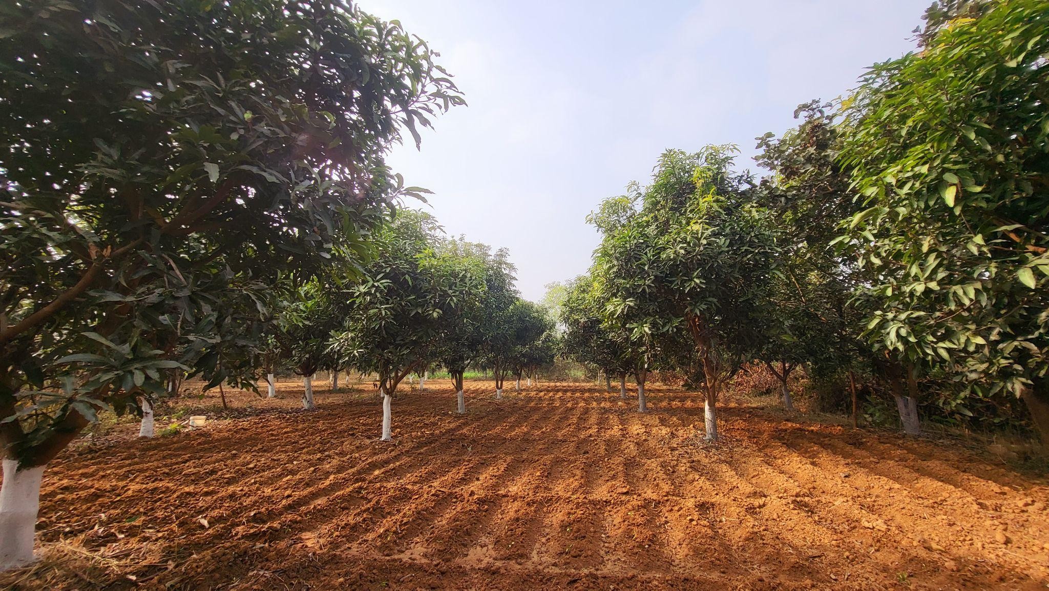
Fig. A mango orchard in Kundatanr
For many women, this was the first time they were directly involved in planning and executing a large-scale development initiative. They contributed to decision-making, coordinated activities with other villagers, and played a central role in turning the community's vision into reality.
As Surubali Mahato reflected, “For the first time, we were not only cooking and managing homes. We were digging pits, measuring land, and taking decisions. Our hands were creating our future.”
The work was physically demanding and technically rigorous. Community members collectively prepared the land, dug pits, planted saplings, applied fertilisers and protective treatments, and carried water under the scorching summer heat.
To ensure the long-term survival and productivity of the plantation, the work followed scientifically designed soil and water conservation practices. Mango saplings were planted at a spacing of 15 × 15 feet, while the land was treated using the 30 × 40 model—an in-situ soil and water conservation technique widely used on unbunded, sloping uplands. Under this approach, the land is divided into plots measuring 30 feet along the slope and 40 feet across the slope. At the lowest point of each plot, a pit is excavated and the removed soil is used to form bunds around it. Typically measuring 5 feet × 5 feet at the base, 7 feet × 7 feet at the top, and 3 feet deep, these pits intercept and store rainwater before it flows downhill. By slowing the velocity of runoff, they reduce soil erosion, enhance groundwater recharge, and improve soil moisture, creating favourable conditions for vegetation growth.
The land treatment is usually carried out after the monsoon, when the soil is moist enough for excavation, and completed before the onset of summer, ensuring the structures are ready to capture the following season's rainfall.
The implementation phase was not without challenges. Disagreements occasionally emerged over land measurements and task distribution. To manage these issues, the villagers formed an informal Plantation Management Committee under the leadership of Maloti Mahato and Surubali Mahato, bringing together all 40 landowners under a common platform. Through regular meetings, transparent decision-making, and continuous dialogue, and dividing the tasks as per turns between all SHG groups, the committee helped maintain unity and collective ownership throughout the process.
By August 2018, all 3,500 mango saplings had been successfully planted. The saplings, predominantly of the Amrapali variety, were provided by the Panchayat and the West Bengal Accelerated Development of Minor Irrigation Project (WBADMIP). The plantation drive generated ₹14,37,927 in wages through 6,231 person-days of employment, with wage payments made under MGNREGA through the Panchayat. The initiative created more local employment than the village had witnessed in the previous three years combined.
Surubali Mahato’s Transformation: Towards transformation and prosperity
Even as a community mobiliser and an emerging leader within the village, Surubali Mahato’s own family grappled with the same water scarcity, livelihood insecurity, and agricultural challenges faced by her neighbours.
Like most families in Kundatanr, Surubali Mahato once lived at the mercy of an unforgiving landscape. Year after year, she watched nearly 100 bighas (25.6 acres) of barren upland stretch endlessly across the village, with monsoon rainwater rushing down its slopes, carrying away fertile soil and leaving behind dry, unproductive land. “The land was thirsty, and so were we,” she recalls.
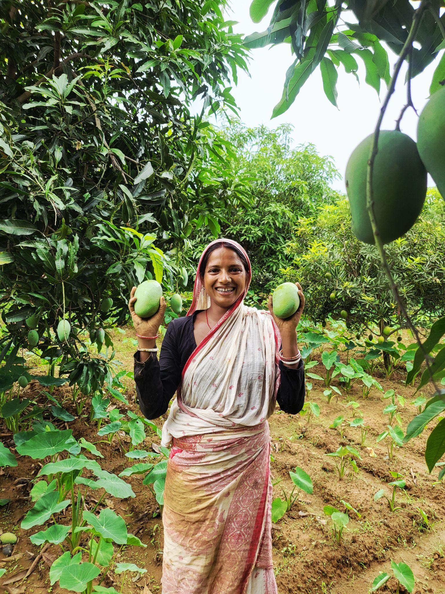
Fig. Surubali Mahato with her freshly harvested mangoes
At 34, Surubali Mahato carries herself quietly. Lean, petite, and usually reserved, she rarely draws attention to herself. Yet beneath her soft-spoken nature lies a strong sense of dignity and determination. When it comes to her rights, whether protecting her land from encroachment or refusing unfair negotiations over machinery rentals, her voice becomes firm and unwavering.
Surubali’s journey as a community leader evolved alongside Maloti Mahato, one of the pioneers of the SHG movement in the village in 2014. After the formation of the first two SHGs, Surubali joined the collective and gradually became deeply involved in watershed planning, Natural Resource Management (NRM) activities, and transect walks across the village. Over the years, working closely with Maloti helped shape her confidence, understanding, and leadership within the community.
Today, Surubali lives with her spouse, Baikuntha Mahato, and their two daughters, who study in Classes IV and VI. The family owns a total of 3.6 acres of land, among which 2.6 acres under plantation and supplements its livelihood with two goats and four hens. Though modest in resources, the household reflects a growing sense of security, ownership, and resilience born out of years of collective effort and transformation.
Strategic Investment during waiting period
Mango plantations demand patience. The trees typically take two to four years before yielding produce, and for the 18 farming families involved in the plantation initiative, this waiting period tested both their resilience and faith in the collective vision. During these years, the fortnightly meetings of the Plantation Management Committee became especially important. They served as spaces where farmers voiced concerns, discussed challenges with possible solutions, and encouraged one another as the saplings slowly began to grow across the once-barren uplands.
It was during this uncertain period that Surubali Mahato made a bold and strategic decision that would eventually inspire many others in the village. Using her savings along with a small loan, she invested in a borewell on her portion of 2.6-acre land within the total 25.6-acre plantation area. While the plantation had been developed collectively, each participating farmer retained ownership and responsibility over their individual landholdings within the larger patch. The collective planning ensured coordination, but farmers were free to take independent decisions to strengthen cultivation on their own plots.
For Surubali, the decision was driven by foresight. She realised that waiting only for mango production would leave families economically vulnerable during the initial years. As the then dense unutilised land is now cultivable, intercropping vegetables between the mango saplings could provide immediate income, but that would only be possible with assured irrigation. Rather than depending entirely on external support for water access, she chose to create her own source of water security.
“People said I was crazy,” she says with a laugh. “Why spend money on a borewell when the trees would not bear fruit for years? But I understood one thing, if I wanted to grow vegetables between those trees, I needed water security even after the monsoon. And for that, I could not keep waiting for others.”
Her decision soon began influencing neighbouring farmers within the plantation area, many of whom started exploring similar investments and farming practices after seeing the results on Surubali’s land.
Intercropping and innovation
While the mango trees slowly matured, Surubali and Baikuntha Mahato, chose not to remain dependent on future returns alone. Instead, they emerged as some of the earliest and most ambitious risk-takers within the plantation initiative by experimenting with intercropping between the young mango saplings.
They dedicated a part of their land, nearly 0.6 acres out of 2.6 acres to intercropping to start with. Between their 348 mango trees, they initially cultivated chilli, brinjal, pulses, and arum, turning the orchard into a productive source of income even before the mango trees started yielding significantly.
The experiment soon began yielding encouraging results. In the first year itself, the family earned nearly ₹15,000 from vegetable cultivation. By the second year, the income had doubled to around ₹30,000. Gradually, neighbouring farmers started approaching the couple for advice and guidance.
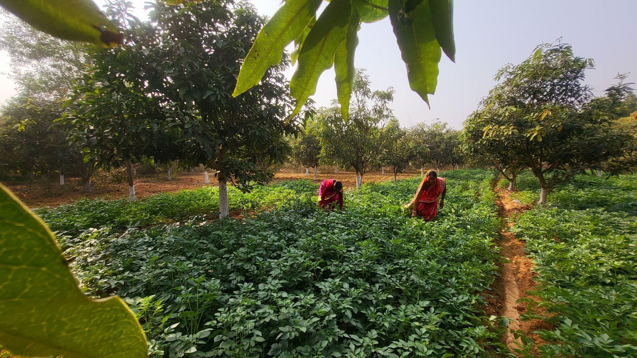
Fig. Intercropping being practised within the plantation area
Over time, Surubali and Baikuntha informally became local resource persons for intercropping practices within the plantation area. They shared practical lessons with fellow farmers; from planning crop cycles around the growing mango trees to understanding irrigation needs and staggering plantations for continuous harvests. Their experience demonstrated an important shift in perspective: the land did not have to remain economically idle while waiting for mango production to begin. Instead, with careful planning and innovation, it could generate immediate income while simultaneously supporting a long-term livelihood investment.
Harvest to patience
Years of collective effort and patience have finally begun yielding visible results for the villagers of Kundatanr. While the broader watershed planning and proposal preparation involved 40 farming families, including farmers from the neighbouring Torang village, the mango plantation itself was implemented across the lands of 18 families. The remaining households also benefited indirectly through improved water availability, wage generation, and opportunities for collective farming linked to the plantation area.
The treatment of the uplands played a particularly important role in strengthening the village’s larger water system. By conserving rainwater and reducing runoff from the ridge areas, the interventions gradually improved water availability in ponds and water-harvesting structures located in the medium uplands and medium lowlands. This created new possibilities for irrigation and diversified farming beyond the plantation site itself.
Over the last two years (2023-25), the mango trees have matured into healthy, productive orchards. For Surubali Mahato, the transformation has been especially significant. Her 348 mango trees produced nearly 3.5 metric tonnes of mangoes. Selling around 2.7 metric tonnes at approximately ₹16 per kilogram generated a substantial source of income of around ₹41,000 for the family, while the remaining produce was used for household consumption and shared within social networks and relatives.
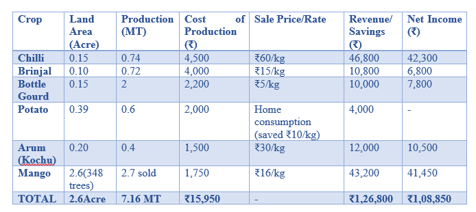
Today, Surubali’s 2.6-acre integrated farming system reflects the larger transformation unfolding across Kundatanr, where degraded uplands have evolved into productive landscapes capable of supporting multiple sources of livelihood and year-round agricultural activity.
Her integrated farming system from 2.6 acres yielded remarkable returns (2025-26):
Lifestyle Transformation
The income transformation enabled profound changes that rippled through every aspect of Surubali's family life. Baikuntha, who once migrated to neighboring villages for daily wage labor, now manages their farm full-time. The dignity of working on their own land, of being present for their children, of building something lasting, this shift has transformed not just their economics but their sense of purpose.
"We don't worry about medical emergencies anymore," Surubali says simply. "We don't sell our goats for emergencies when something unexpected happens. That fear, that constant fear is gone." The psychological shift from survival mode to planning mode has been as transformative as the financial gains. They wake up now without the knot of anxiety in their stomachs, without wondering how to feed the family through the lean months, without the shame of borrowing from neighbors.
Collective Prosperity: Beyond Surubali’s Success
Collective Economic Impact
The transformation witnessed in Kundatanr extends far beyond individual success stories. What was once considered barren and economically unproductive land now collectively generates an estimated annual income of nearly ₹5,86,850 for the 18 direct beneficiary families associated with the mango plantation. This includes approximately ₹4,09,850 from mango sales and nearly ₹1,77,000 through intercrops cultivated within the orchard spaces. In addition, families have significantly reduced household expenses through the regular consumption of home-grown vegetables and pulses, strengthening both food security and nutritional access.
Institutional Strength and sustainability
A key reason behind the long-term sustainability of the initiative has been the continued strength of community institutions. The Plantation Management Committee, which began as an informal coordination mechanism during implementation, has now evolved into a formally registered community institution. The committee continues to meet fortnightly, collectively managing plantation maintenance, pest control, irrigation planning, market coordination, and security arrangements.
The community has also continued engaging with multiple government departments and external institutions to strengthen and expand its development efforts. Plans and proposals are regularly prepared and submitted to departments such as the Department of Agriculture, WBADMIP, the Block Office, other local running CSOs like ICICI foundation and the Gram Panchayat. Over time, convergence with government programmes, CSR initiatives, NGOs, Agriculture Dept. and community-based institutions has further strengthened the village’s resource base. As a result of these continued efforts, two additional water-harvesting structures were created last year itself and multiple seeds like that of lentil, mustard, groundnut and sunflower have been mobilised through WBADMIP and Agriculture Dept. for collective farming for last years.
Importantly, the village community did not stop with the initial watershed intervention. The planning exercises conducted during the watershed phase created a long-term vision for resource management, which villagers continue to pursue proactively by reaching out to different organisations and institutions for implementation support. Today, the 18 plantation beneficiary families continue earning through intercropping, vegetable cultivation, and diversified farm-based livelihoods.
Conclusion
Surubali Mahato’s journey, from a subsistence farmer struggling with water scarcity and uncertain livelihoods to a confident agricultural entrepreneur earning a net annual income of nearly ₹1.08 lakh from her 2.6-acre integrated farming system reflects the emergence of a true Lakhpati Didi. Yet her story is not merely an individual achievement; it represents the power of collective action, community-led planning, and long-term ecological restoration.
Perhaps the most powerful symbol of this transformation emerged recently, when villagers and plantation farmers from Bandhudih, the very village that once hosted Kundatanr farmers for exposure visits and learning, visited Kundatanr to understand its plant maintenance and intercropping practices. During the interaction, the community members from Kundatanr shared with a sense of pride and humour, “Earlier, we visited your village to learn how to begin. Today, through our hard work and consistency, you have come here to learn from us.”
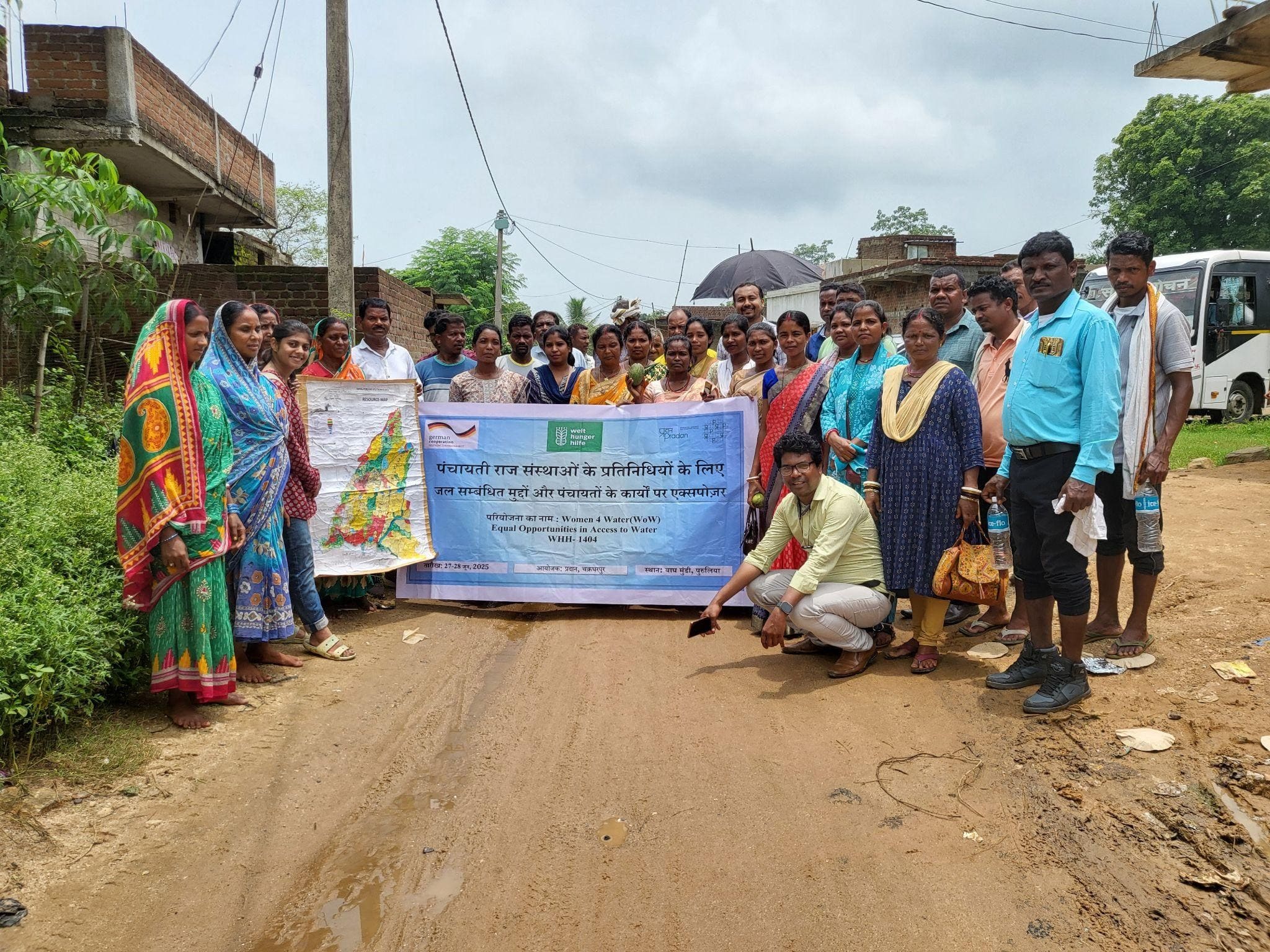
Fig. Exposure visit from neighbouring teams to Kundatanr
The moment reflected more than just agricultural success. It marked a reversal of confidence, knowledge, and leadership, where a village once struggling with barren land and migration had itself become a source of inspiration for others.
The experience of Dava village demonstrates that watershed development is not only about conserving water or treating land. At its core, it is about restoring dignity, strengthening livelihoods, and building resilient rural economies. The village’s transformation shows how water stewardship can become the foundation for agricultural prosperity, how women’s leadership can sustain community institutions, and how collective vision and participation can convert degraded landscapes into thriving ecosystems of opportunity.
About the Author