The Art of Slowing Rain: Lessons from a Watershed in Madhya Pradesh
-Anurudh Kumar Shastri, Executive, PRADAN
Background
Niwas block in Madhya Pradesh's Mandla district receives more than 1,200 millimetres of rainfall every year, an amount that should, in theory, sustain farming across seasons. Located in the eastern reaches of the state, Niwas falls under the Northern Hills of Chhattisgarh Sub-Agro Climatic Zone, a landscape of light alfisol soils that struggle to hold water and are easily worn away by rain. The land here does not lack rain. What it lacks is the ability to hold it.
The problem is written into the terrain itself. Steep slopes, somewhere in between 10% to 25%, shed water faster than the soil can absorb it. Within hours of a downpour, rainwater rushes through natural channels and drains away, leaving fields parched long before the next clouds arrive. This is not just a local inconvenience; it reflects a wider constraint shaping farming across many such landscapes. For the roughly 80% of households in Niwas whose livelihoods depend on agriculture, the mismatch between how much rain falls and how much the land retains has long kept farming locked into a single season.
Farmers here grow paddy, maize, and vegetables during the kharif season, relying entirely on monsoon rains. On the uplands, where soil fertility is low, many households cultivate Kodo and Kutki, traditional millets that require little or no chemical inputs and can withstand difficult conditions. Mandla district has, in fact, designated these millets as its ODOP (One District One Product) crop, recognising their cultural and nutritional significance.
Come the rabi season, wheat, lentils, and vegetables are grown where some soil moisture lingers. However, cultivation during rabi and summer has historically remained limited. While systematic groundwater data over time is still evolving, farmers consistently report a decline in accessible groundwater levels over the years, making irrigation less reliable. In contrast, areas closer to recent interventions show improved crop health and productivity, suggesting that enhanced water retention and management can partially offset these constraints.
How can a region receiving 1,200 mm of rainfall run dry? The answer lies not in how much rain falls, but in how it falls and when. Long-term climate analysis of the Thanamgaon watershed, which covers three villages across two gram panchayats in Niwas block, shows that while total annual rainfall has remained broadly stable over the past three decades, its pattern has shifted in troubling ways. More than 90% of rain arrives during the early South-West Monsoon (June and July), but the later monsoon months (August and September), critical for crop growth, have seen a decline in rainfall. Meanwhile, rain is falling on more days but in smaller amounts per day, a shift that does little to recharge the soil or groundwater.
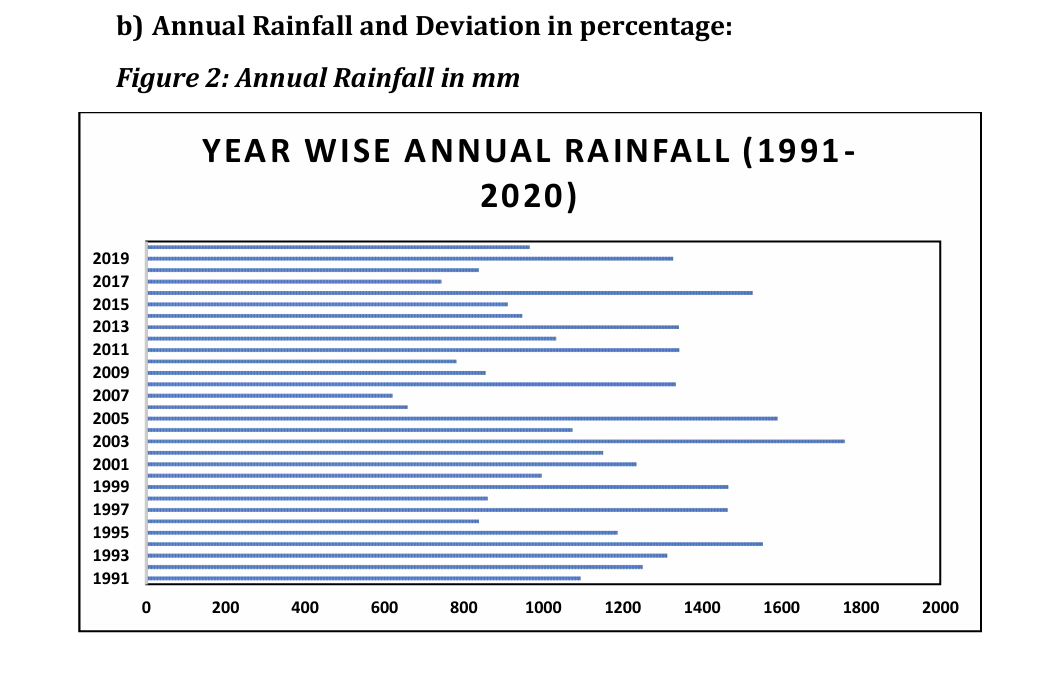
Photo: Annual rainfall (in mm) in Niwas block
PRADAN began working in Niwas block in 2024 through a watershed intervention aimed at addressing these challenges at a systems level. As part of the initial phase, a collaboration with FARMBridge* was undertaken to better understand the evolving climate context and its implications for local agriculture. Field surveys and data analysis were carried out to assess rainfall patterns, monsoon variability, and the need for climate-proofing interventions within the watershed.
The findings point to further disruption ahead: delayed monsoon onset, more rainfall occurring outside the main growing season, and rising temperatures, all of which increase the risks for rain-fed farming communities with limited buffers against climate shocks.
Past efforts to address this were well-intentioned but incomplete. Over the years, soil and water conservation structures were implemented primarily through programmes supported by NABARD*, with support from line departments and local institutions like Civil Society Organisations (CSOs) and Community Based Organisations (CBOs). Interventions included stone bunds, gully plugs, contour trenches, percolation tanks, farm ponds, and dugwells, constructed at different points across the landscape. Contour trenches were created on the uplands to slow surface runoff, while dugwells were built in lower and mid-slope areas to capture water closer to fields.
However, these efforts were not systematically planned using a ridge-to-valley approach or implemented in a cluster or patch-based manner. Structures were built in isolation, without a connected watershed plan or sequencing that would allow them to function as an integrated system. Without first treating the ridgelines and ensuring continuity across the landscape, much of the rainwater continued to escape before it could be effectively retained and used. As a result, agriculture remained largely single-season, and the land continued to degrade over time.
Climate Variability as a Compounding Risk
The Thanamgaon watershed is more than a piece of land. It is a window into a much larger challenge, one playing out across rain-fed farming regions all over India, where shifting weather patterns are quietly dismantling livelihoods built over generations.
The data from the past three decades tells a nuanced story. Total annual rainfall in the region has not dramatically declined, but its pattern has shifted. Deficit years are becoming more frequent, disrupting what were once more predictable monsoon cycles. While most rainfall still arrives during the South-West Monsoon, its distribution within the season has become uneven, with critical crop months receiving less reliable moisture. Climate projections suggest these stresses may intensify, with delayed monsoon onset, rising temperatures, and more rainfall occurring outside the main growing season, making rain-fed farming increasingly precarious.
In Niwas block, where nearly 80% of households depend on farming for their livelihoods, these shifts are not abstract. They show up in thinner harvests, in wells that run dry earlier each year, in the anxiety that settles over a village as the monsoon delays its arrival.
Responding to this kind of challenge requires more than building a structure here or a bund there. It requires treating the landscape as a system, starting from the ridgeline at the top and working downward to the valley floor, so that water is slowed, captured, and absorbed at every stage of its journey. This approach, known as ridge-to-valley watershed treatment, is the foundation of the work underway in Niwas. Rather than isolated structures scattered across the land, the idea is to create a connected chain, contour trenches on the upper slopes to slow runoff, check dams and percolation tanks in the middle, and farm ponds and dugwells in the lower reaches so that rainwater is made to "walk" through the land rather than race through it. The goal is not just to conserve soil and water, but to rebuild the conditions under which farming can be reliable, productive, and worth investing in.
The Watershed Intervention
While working in the region, closely with the community, the work began to take shape around a simple yet powerful question: in a landscape where rainwater escapes almost as quickly as it arrives, how can it be slowed down long enough to become useful? It was a question that seemed technical at first, but over time, I began to see it as something deeper; about patience, about working with the land, and about learning to hold what is otherwise fleeting, by creating small, distributed water-harvesting structures such as contour trenches, check dams, and bunds that reduce runoff, increase soil moisture, and allow water to gradually percolate into the ground.
The answer lay in treating the problem at its source. Two degraded hill systems, spanning over 15 hectares, had long been the starting point for runoff that stripped topsoil, dried out fields, and limited groundwater recharge. Previous efforts had focused on structures in the lower parts of the landscape, but water that has already gathered speed and volume is far harder to manage. This intervention chose a different logic: start at the top, at the ridgeline, and work downward.
This ridge-to-valley approach is captured in a phrase that guided the entire effort, "daudte pani ko chalana aur chalte pani ko rokna" (slow the fast water, and hold the flowing water). Rather than letting rainwater race downhill and out of the system, the goal was to intercept it early, reduce its speed, allow it to seep into the soil, and gradually recharge the groundwater that farmers and their crops depend on through the dry months.
The intervention was carried out under NABARD* which has increasingly recognised that lasting rural livelihoods depend not just on wages but on rebuilding the natural resource systems that underpin farming. The work reflects this shift, using public investment not to create isolated structures, but to restore the hydrological health of an entire watershed.
As this experience in Niwas block shows, watershed planning can serve not only as a technical solution for water management, but as a guiding framework for improving the effectiveness, sustainability, and livelihood outcomes of large-scale public investments.
The intervention was designed around seven core objectives:
- To reduce surface runoff from hill slopes
- To arrest soil erosion at its source in upland areas
- To enhance in-situ rainwater conservation and groundwater recharge
- To enable rainwater to percolate into the ground where it falls
- To reduce agriculture's dependence on a narrow monsoon window
- To improve land productivity and agricultural sustainability
- To strengthen community-led natural resource management systems
Contour Trenches and the 30×40 Model
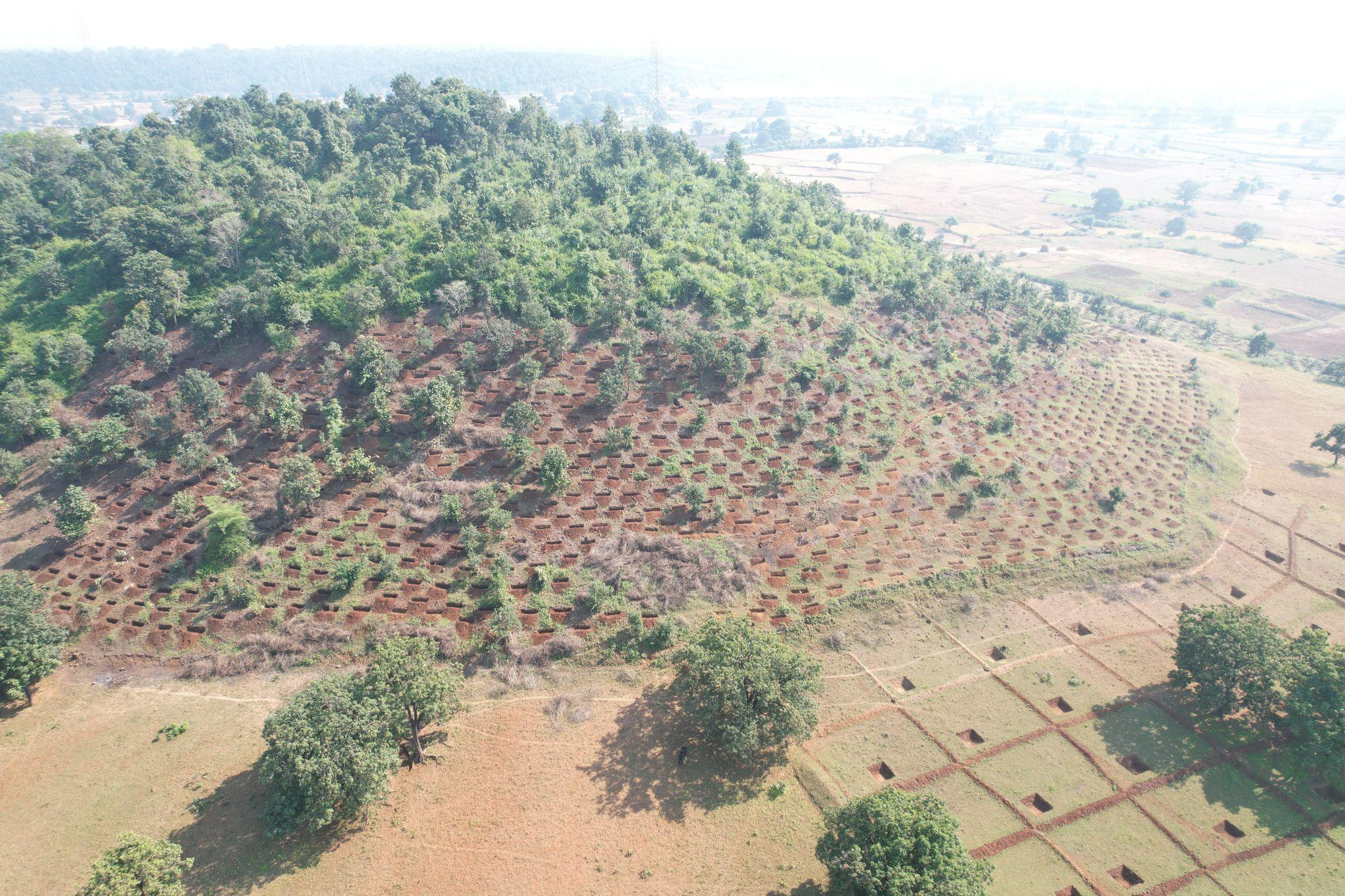
The primary tool of this intervention was the contour trench, a pit dug along the natural contour lines of a slope to intercept runoff before it can gather force. From July 2024, a total of 5,495 such pits have been constructed over the two hill systems. Each pit measures six feet long, two feet wide, and one and a half feet deep, dimensions calibrated for slopes between 10% and 25%, which describes much of the terrain here. Laid in lines that follow the curve of the land, these trenches act as a series of small holding points. Rainwater settles into them, slows down, and gradually percolates into the soil rather than rushing downhill and carrying the earth with it.
Photo: A treated hill slope with contour trenches and percolation pits
Alongside the contour trenches, a 30×40 model water-harvesting structure was introduced to capture and retain runoff at key points where the slope begins to level out. Each structure covers an area of roughly 30 feet by 40 feet and includes a central percolation pit designed to enhance groundwater recharge. The pit measures about 7×7 feet at the top, tapering to 5×5 feet at the bottom, with a depth of approximately 3 feet. This design allows rainwater flowing across the plot to collect and slowly percolate into the soil, helping reduce soil erosion while improving soil moisture. These structures are typically constructed in medium upland areas with slopes below 8 percent. The surrounding area is then used for agroforestry plantations and seasonal crops such as pulses, allowing farmers to combine soil conservation with productive land use.
The aim, at its core, is to widen the window within which farmers can grow, moving from a single anxious season of rain-fed cultivation toward a more stable, year-round relationship with their land.
Estimated Water Conservation Potential
Together, these pits have the potential to retain and percolate more than 36 lakh litres of rainwater annually, an estimate based on the first year of monsoon, with the potential to increase over time. This is not water used directly for irrigation, but water that seeps slowly into the ground, reducing soil erosion in the uplands and recharging local aquifers. By slowing runoff and conserving both soil and moisture, these structures help improve the overall health of the landscape. Farmers cultivating land in and around treated areas have begun to observe better crop conditions, with improvements in plant health and production quality over time.
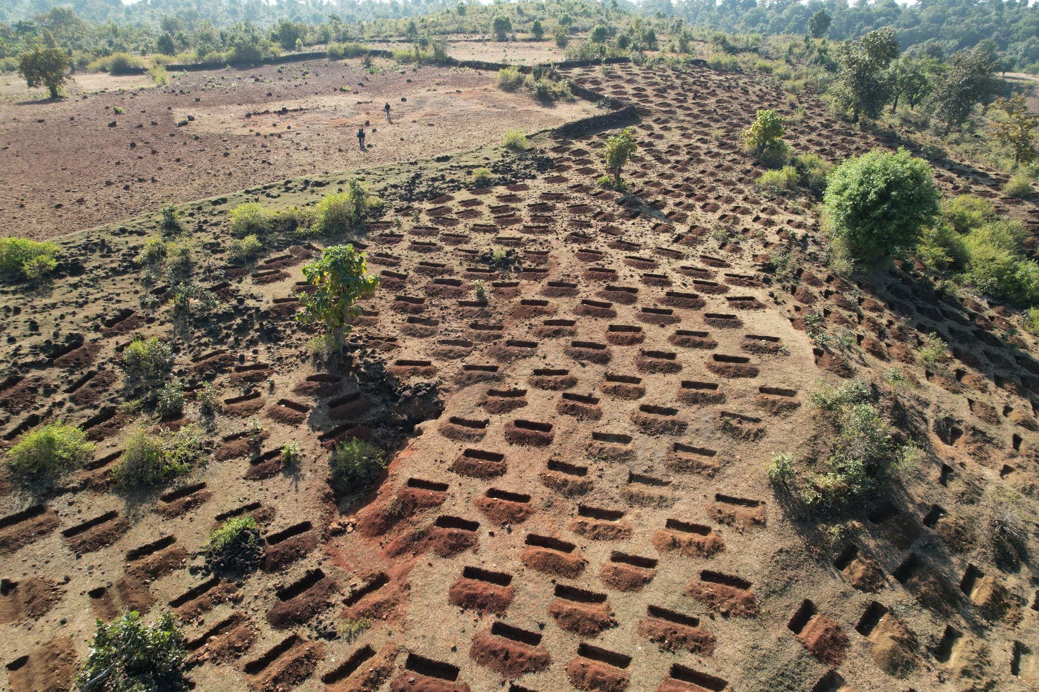
Photo: A grid of Staggered contour trenches across the slope
This is the power of working with the landscape. No single structure changes very much on its own. But when micro-interventions are planned in sequence, aligned with how water naturally moves across the terrain, their cumulative effect reshapes the hydrology of an entire hillside.
Community at the Heart of Change
A watershed intervention can be technically sound and still fail. Structures fall into disuse when no one feels responsible for them. Silt accumulates in trenches that no one clears. Bunds are breached and left unrepaired. The difference between an initiative that lasts one season and one that lasts a generation often has less to do with engineering, but with who feels ownership over the work. Over time, I began to realise that what we were building was not just physical structures, but relationships between people and land, and between effort and continuity.
In the village of Thanamgaon, community involvement was built into the intervention from the very beginning. Before a single pit was dug, local men and women were involved in walking the land and identifying where structures should be placed. This was not a formality. Villagers who have farmed the same slopes for decades carry knowledge that no technical survey fully captures, where water pools after heavy rain, which patches of soil crack earliest in summer, where the land has slowly been losing its depth over the years. That knowledge shaped where the contour trenches were laid and how the structures were sequenced across the hillside.
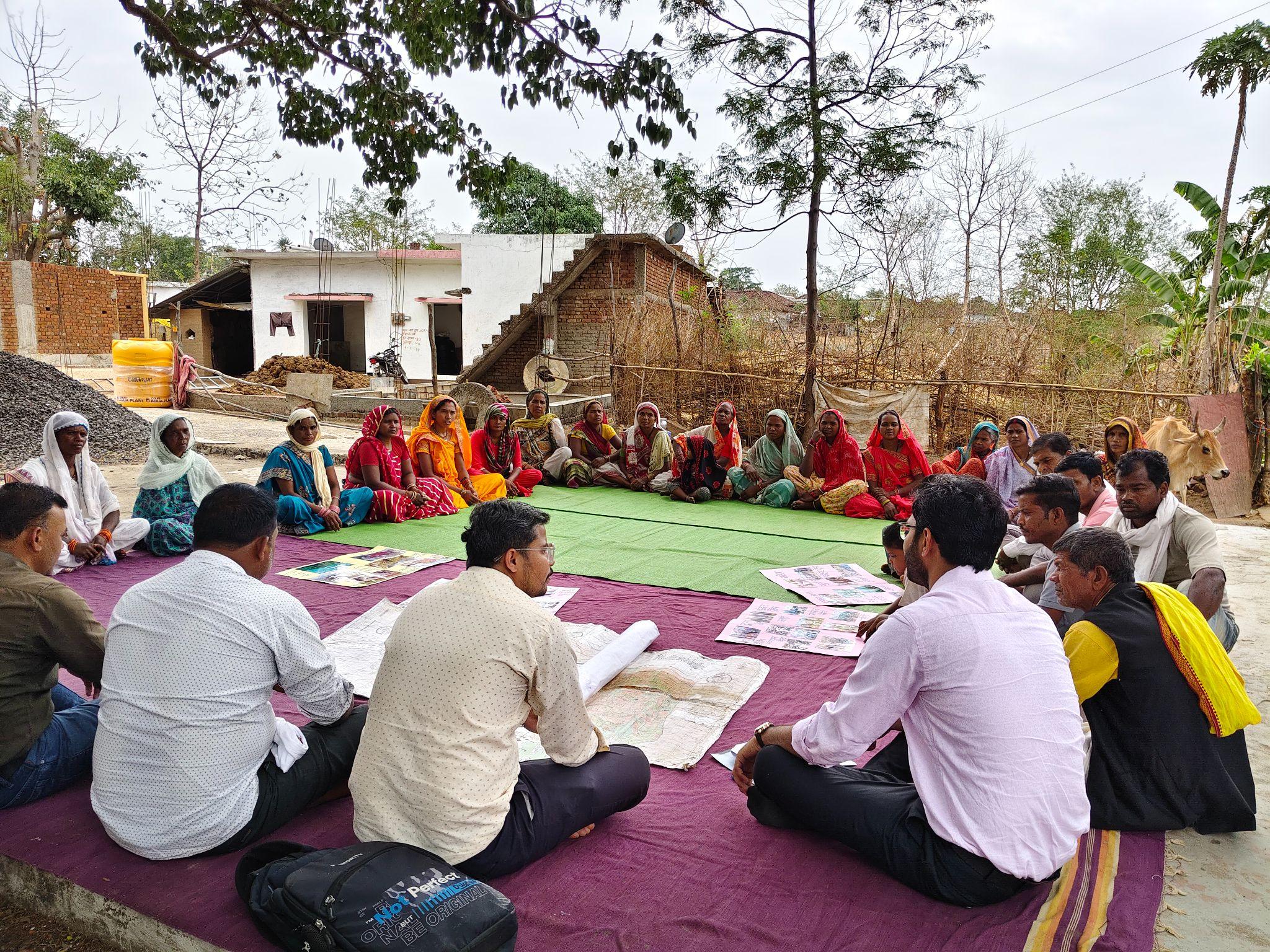
Photo: Community members engaging in discussion to understand and review the intervention
During construction, community members contributed their labour directly; not as hired hands, but as workers who understood what they were building and why. Working in groups organised through the Watershed Development Committee, they learned to read contour lines, to judge the correct spacing between trenches, and to build to the right dimensions so that water would settle and percolate rather than overflow and erode. Skills that began as instruction became, over weeks of practice, something closer to expertise. There was a quiet shift here, from participation to ownership that could not be measured, but was deeply visible.
Monitoring did not stop once the structures were built. Village members took responsibility for checking the trenches after rain, clearing blockages, and flagging any damage early, before small problems became large ones. This ongoing stewardship is what turns a set of physical structures into a living, functioning system. It also revealed that sustainability is less about design, and more about who continues to care once the project recedes.
Parwati Uikey, Secretary of the Thanamgaon Watershed Development Committee, puts it simply:
"Bhaiya, hamare gaon mein itna kaam ho raha hai jisse bacchon ke bhavishya ke liye zameen bach payegi, toh bacchon ko bahar nahi jaana padega." (So much work is happening in our village now, work that will save the land for our children's future. Our children won't need to leave and go elsewhere.)
Her words carry the weight of something that development workers often struggle to quantify: the feeling that the land is worth staying for. In a region where young people have long drifted toward cities in search of work, the idea that restored land could keep families rooted is not a small thing.
Keshri Bai, another member of the Village Watershed Committee, stood at the edge of the newly deepened farm pond and said:
"Talab ko itna gehra pehli baar dekha hai. Bees saal tak nahi purega ye." (I am seeing the pond this deep for the first time in my life. This will not fill up with silt for twenty years.)
Twenty years. For a woman who has watched ponds silting up and drying out season after season, that is not just a technical observation, it is a measure of hope. It speaks to the difference between work done quickly and work done well, between a structure built to meet a target and one built to last.
Challenges Faced During Implementation
Implementing the watershed works was neither quick nor easy. The two hill systems in Thanamgaon are rocky and steep, terrain that looks dramatic from a distance but is punishing to work on. Digging more than 5,495 contour trench pits by hand into slopes where the soil gives way to stone within a foot or two of the surface meant slower progress, more effort per pit, and a constant need to adapt technique to what the ground allowed. On some stretches, workers had to chip through rock before they could shape a trench to the right dimensions. There were no shortcuts, a pit dug too shallow or too narrow would not hold water effectively, and the careful spacing between trenches had to be maintained even where the terrain made it inconvenient.
Rainfall itself created an unpredictable working rhythm. The intervention depended on the monsoon to demonstrate its value, but the same rains that filled the newly dug trenches also made the slopes slippery and dangerous to work on. On days of heavy rainfall, work had to stop entirely. Then, when the rain eased and the ground was workable again, the window to dig and reinforce structures before the next downpour was often short.
Labour availability presented its own complications. In a farming community, the months of the kharif season are among the busiest of the year. Transplanting, weeding, and harvesting all demand hands, and a family that has to choose between wage work on the watershed and attending to their own fields will almost always choose their fields first. Getting the construction calendar to work around the rhythms of local agriculture required constant flexibility, planning intensive work during the gaps between farming peaks, and adjusting targets when the season demanded it.
Perhaps the most delicate challenge was one that no technical plan fully prepares you for: the initial hesitation of the community itself. Not everyone was convinced that this intervention would be different from the scattered structures that had come before and delivered little. Some were sceptical about the ridge-to-valley approach, having seen bunds and trenches built on the lower slopes year after year with modest results. Others were cautious about committing their labour to work whose benefits would not be immediate or visible in the first season.
These doubts were addressed not through persuasion alone, but through presence. Field staff stayed close to the work, offering technical guidance on site rather than from a distance. Community meetings created space for questions, for frustration to be voiced, and for early results, however small, to be shared and discussed. As the first rains filled the newly dug trenches and the difference in runoff became visible on the slopes, scepticism began to soften. Trust, in the end, was built the same way the trenches were; gradually, carefully, and one conversation at a time.
Early Evidence and What the Land is Showing
It is still early. The contour trenches have weathered one monsoon season, and the deeper shifts in groundwater levels, in crop yields, in the long-term health of the soil will take more seasons to measure with any confidence. No comprehensive data has yet been compiled. What exists instead are observations: from field staff who have walked these slopes before and after the rains, and from the farmers who live on this land and know its moods better than any instrument.
What they are seeing is encouraging. On the treated hill slopes, erosion appears visibly reduced, and the topsoil that once washed away in brown streams after a downpour is staying closer to where it fell. The soil on the upper slopes feels different underfoot in the weeks after rain: damper, more held together. Villagers describe noticing that the land stays moist longer than it used to, and that the trenches are holding water rather than simply filling and overflowing.
In the fields downstream, farmers have observed that soil moisture is lasting further into the post-monsoon period than in previous years, a small but significant shift for households trying to extend their growing season beyond kharif. As this is the first year of the intervention, these changes are still emerging, and no major shifts in cropping patterns or scale are evident yet. However, early signs such as improved plant health and more stable soil conditions have been noted across plots near treated areas.
Looking ahead, the expectation is that improved moisture retention will enable gradual diversification and expansion of rabi and summer cultivation on lower slopes. On the upper slopes, where direct cultivation remains limited, the focus is on stabilising the land through soil and water conservation, along with planned agroforestry and suitable crop interventions over time.
These are not yet numbers. They are signals, the kind that experienced farmers and field workers learn to read before the data catches up. And in a landscape that has been losing ground, slowly and steadily, for decades, even these early signals matter.
The monitoring continues. Groundwater levels, crop productivity, and the condition of the structures themselves are being tracked across seasons.
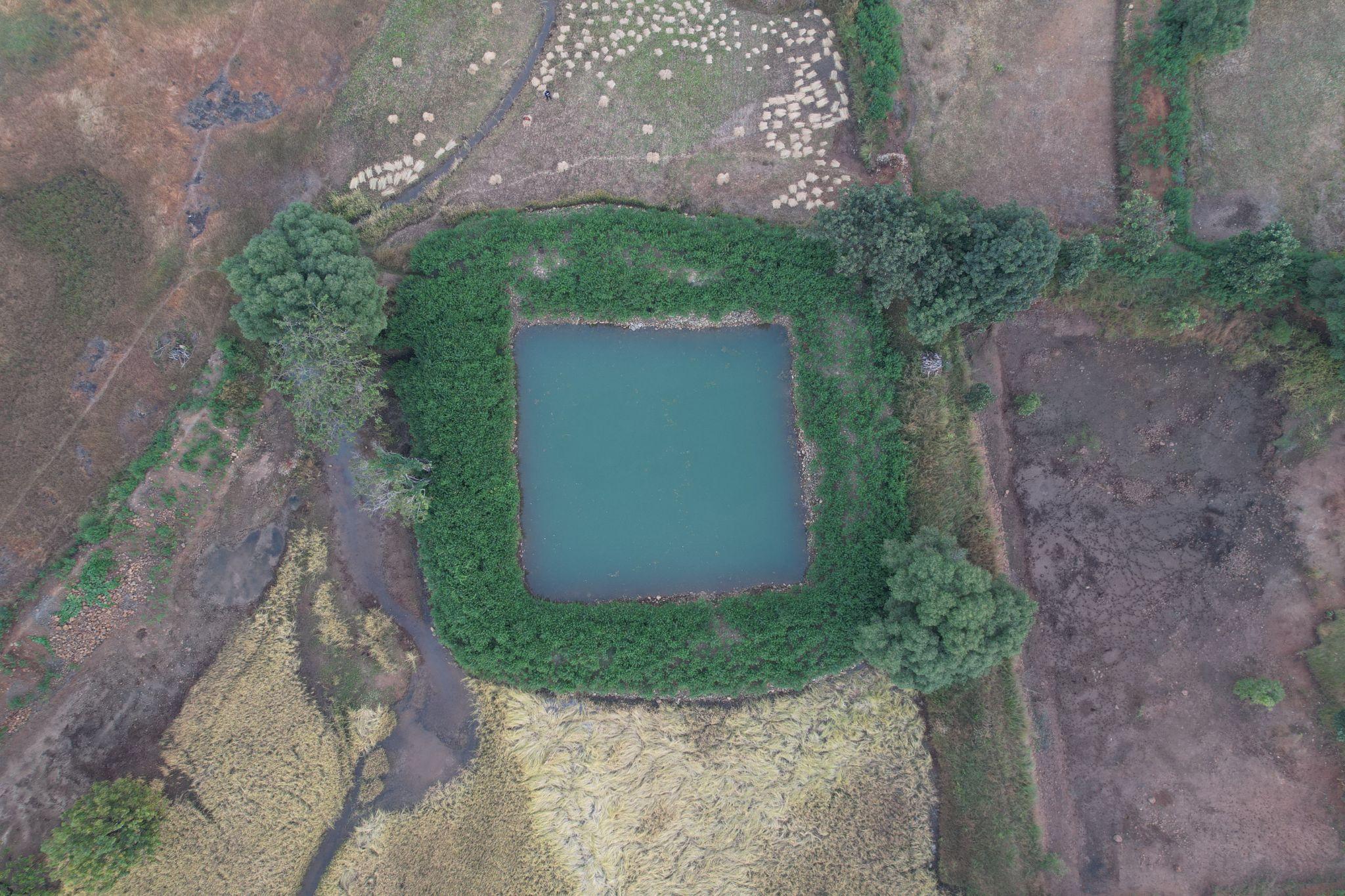
Photo: A farm pond capturing and storing rainwater at lowland
Conclusion and the Road Ahead
The work in Thanamgaon is, in one sense, a story about water. About how 36 lakh litres of rainwater that once fled the land can be made to stay. About how 5,495 small pits, dug by hand into rocky hillsides, can begin to change the relationship between a farming community and the season they depend on.
But it is also a story about something harder to measure, about what becomes possible when a community is trusted as a partner rather than treated as a beneficiary. The villagers of Thanamgaon did not simply receive a watershed intervention. They shaped it, built it, and are now watching over it. That shift from externally driven project to community-managed resource may prove to be the most durable outcome of all.
The experience raises questions that matter well beyond this one block in Mandla district. What happens when watershed planning begins at the ridge rather than the valley? Can a connected, cluster-based approach to soil and water conservation become the standard rather than the exception in India's rainfed regions? And how can climate data projections about delayed monsoons, shifting rainfall patterns, rising temperatures become a routine part of local land and water planning, rather than remaining the preserve of researchers and policy documents?
The Niwas watershed does not answer all of these questions. But it does offer a direction. The future of water security in rain-fed landscapes may lie not in finding new sources of water, but in helping the land hold on to the rain it already receives. That principle; simple in statement, demanding in practice is what the ridge-to-valley approach embodies.
To build on what has begun, the following steps will be critical in the seasons ahead:
- Regular maintenance and strengthening of contour trench structures as they settle through successive monsoons
- Plantation and vegetative measures on treated slopes to further stabilise soil and reduce erosion naturally over time
- Promotion of water-efficient and climate-resilient cropping systems in downstream areas, suited to a gradually lengthening growing season
- Long-term monitoring of groundwater levels, soil moisture, and crop productivity to build the evidence base for future investments
The treatment of more than 15 hectares across two degraded hill systems is not merely an infrastructure achievement. It is the beginning of a longer effort to restore the ecological health of a watershed, strengthen the resilience of the farming families who depend on it, and demonstrate that in climate-vulnerable regions across India, durable change is possible one ridge, one trench, one community at a time.
*About FarmBridge- FARMBRIDGE SOCIAL SUPPORT FOUNDATION (FSSF) is a Section-8 Non-Profit Company incorporated in 2015 with a vision of empowering the Highly Vulnerable Rural community with Climate Change Adaptation and Climate Risk Mitigation. It has identified various innovations and technologies to increase the adaptation for the farmers in the climate change phenomenon. These technologies also enable farmers to reduce their water consumption in irrigation, reduce the carbon emissions in agriculture & increase in soil health.
*About NABARD- NABARD is India’s apex development bank, established in 1982 to promote sustainable and equitable agriculture and rural development. In its journey of more than four decades, the premier development financial institution has transformed lives in Indian villages through agri-finance, infrastructure development, banking technology, promotion of microfinance and rural entrepreneurship through SHGs & JLGs and more. It continues to aid in nation building through participative financial and non-financial interventions, innovations, technology and institutional development in rural areas.
About the Author

Anurudh Kumar Shastri is a development practitioner and alumnus of the National Institute of Technology (NIT), Bhopal, with a B.Tech in Mechanical Engineering. With over 6.5 years of field experience, he works with PRADAN, contributing to grassroots development initiatives.
His areas of interest include institution building, stakeholder management, youth employment, watershed management, and livelihood promotion, with a focus on sustainable and participatory approaches. He has also delivered lectures on the SDGs at various government institutions.
Anurudh is a published writer and author, with articles featured in national platforms and a book to his credit (2023). He is also recognized as a Hindi poet known for his socially rooted expressions.